
Nele summarizes her insider tips for sightseeing in the south of Iceland
Tips for secret sightseeing spots in South Iceland
Iceland never ceases to amaze me with its diversity and seemingly inexhaustible natural wonders. In each area of the volcanic island you could spend a whole vacation and always discover something new. Especially in the south, one highlight follows the other. The downside of this is the crowds at the “must-see” attractions like Geysir, Skógafoss, Diamond Beach and so many more. This year, I have been looking for alternatives that are just a stone’s throw from the Ring Road and not inferior in beauty to the well-visited attractions. At many of these places I have been able to spend time there alone. Of course, these places are also becoming more and more famous, but if you are looking for magical places that are not quite so crowded, here are 6 tips for a road trip in the south. All places can also be found on Google Maps.
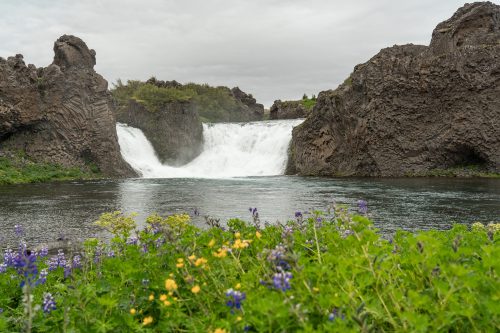
Hjálparfoss
A picturesque waterfall between basalt columns. Here the river Fossá í Þjórsárdal falls 9 meters and split into two arms into a large basin. Around the river, a few lupines also decorate the view at flowering time (lupines bloom in Iceland from mid-May into June. A blessing as a beautiful photo motif, though a curse for Iceland’s flora, as they are an invasive species displacing native plant life).
Hjálparfoss is very easily accessible from the parking lot, which is only a few steps away, and now even has some viewing platforms.
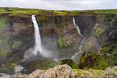
Háifoss
The sight of the gorge in Fossardalur (Engl. “Valley of the Waterfalls”) is overwhelming. Háifoss plunges 122 meters into the depths, making it Iceland’s third-highest waterfall. Right next to it roars the Granni with a drop of 100 meters. From the parking lot, you can walk down to the edge of the cliff on a marked trail for just one minute. In many places you can test your head for heights. The cliff edge is not secured and you can get as close as you feel safe. You should take some time to walk along the trail that runs parallel to the gorge. Just a few meters further, new perspectives of the spectacular view keep taking your breath away. When the sun is shining, rainbows through the spray of the waterfalls make the scenery look almost surreal.
The road to the parking lot is not an official F-Road, but along the gravel road one discovers signs recommending a 4×4 car. I ventured out in my regular car in good weather and it took me almost 20 minutes to cover the bumpy 7 kilometers of Road 332. However, in bad weather, the road conditions can be even worse, where it is better to park the car and walk if you are driving without a 4×4.
If you prefer to walk anyway, you can take a day hike to the Háifoss gorge. The hiking trail starts in Stöng, a historical site where a longhouse of the first Vikings has been rebuilt. After about 10 kilometers you will reach the gorge where Háifoss and Granni thunder into. For the way there and back you should plan 5-6 hours and be prepared that the hiking trail, which leads along the riverbed, is not always well recognizable.
If the distance from Stöng is too long, but you want to get as close as possible to Háifoss at its foot, you can also follow the path from the parking lot that leads down into the gorge. But this path should not be underestimated either, as it holds a steep descent of almost 120 meters and debris avalanches can come off the slope. The path is not always recognizable and some stamina is required. One hour each way should be allowed for.
No matter from where you look at the gorge, Háifoss and Granni, you will experience views that are difficult to capture in a photo.
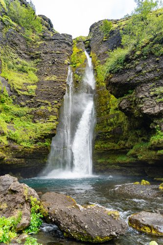
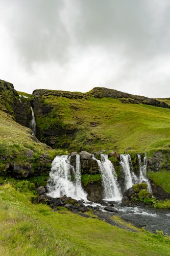
Gluggafoss (Merkjárfoss)
Gluggafoss (Engl. “window waterfall”) is also known as Merkjárfoss. It is named after the small river Merkjá, which falls there over three steps. A paved small path leads to the lower two waterfalls, which are 8 meters and 76 meters high. From the first terrace, in good weather, you can see as far as the Eyjafjallajökull glacier. If you like, you can even stand behind the lower waterfall from there.
Gluggafoss is very easily accessible. From road 261, after 300 meters, you come to a small parking lot where the small stairway path begins.
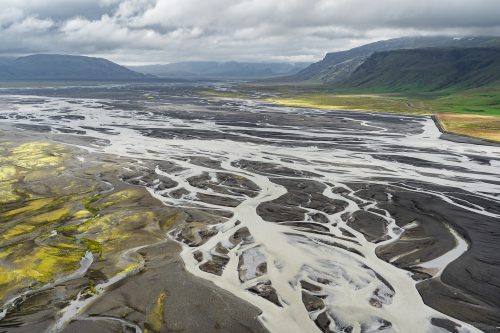
Stóra-Dímon
The 178 meter high mountain is a landmark in the middle of an alluvial plain. What you can not guess from below is the spectacular view from the top. The river delta is literally at your feet once you have made the short but quite steep climb along a small trail. On the mountain itself, you can wander around and marvel at the numerous river forks.
Near the mountain, the Saga Center Hvolsvöllur has erected a sign that tells of battles from the area that were fought during the time of Iceland’s settlement.
They were described in the most famous Icelandic saga, Njáls Saga. The mountain was called Rauðuskriður at that time.
Right next to the road 250 is Stóra-Dímon and a parking place for cars, from where you can start walking on the path on the southern slope of the mountain.
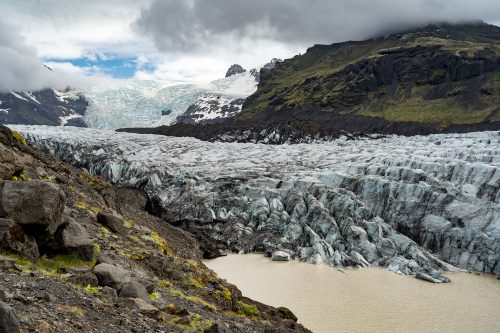
Svínafellsjökull
Svínafellsjökull is a glacier tongue of Vatnajökull, Iceland’s and also Europe’s largest glacier, excluding the polar regions. You can walk to the terminal moraine of the impressive glacier spur. Only 2 kilometers you have to walk from the ring road along a gravel road. However, even after the short distance one stands in the face of dramatic nature. You can go exploring at the end of the trail around the glacier rim lake to the right or, with a little caution, hike along the slope to the left. The glacier towers in the background. Svínafellsjökull comes from the highest mountain in Iceland, Hvannadalshnúkur at 2,110 meters. If you are a “Game Of Thrones” fan, you will not miss the fact that many scenes from the hit series were filmed at this location.
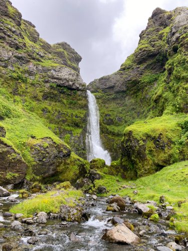
Íráfoss
Íráfoss is already visible from the ring road and yet you are often alone in front of the waterfall. To get to it, you take a short detour along road 246. From the road and an inconspicuous parking bay, it is only a 250-meter walk to stand directly at the 60-meter-high Íráfoss. If you prefer to see it from horseback, you can find horseback riding tours online.
It is important to leave the places as they were found. This applies in principle everywhere in nature. But especially in places where the infrastructure is sometimes not quite as advanced as around most of the main attractions, it is in our hands to protect these places. With three simple steps, we can minimize our impact on nature and our surroundings.
Stay on the trails: If possible, do not leave the designated hiking trail and stay away from sensitive Icelandic moss. You do not have to make your own path. In all places there is at least one small trail that leads up to the point of interest.
Dispose of waste properly: On a (day) hike, for example, you can carry a few bundles of toilet paper or tissues and a small zippered plastic bag. Just put the used toilet paper in the bag and throw the paper in the toilet when you get home or to a trash can.
Do not take anything with you: Leave rocks, plants and other natural items as you find them. The adage “leave nothing but footprints, take nothing but pictures” applies everywhere, and even better is to leave as few footprints as possible.
And as I mentioned at the beginning of the text, the list of waterfalls, gorges and mountains I still want to see in the area is not getting shorter after one visit, but longer. Already I can’t wait to visit and photograph new places, undiscovered for me so far.
Thank you, dear Nele, for your helpful tips and explanations!
Images & text: Nele Mahnke
Nele’s Instagram Page
A land of fire and ice, with more sheep than inhabitants, characterized by a unique nature! This is just a brief description of such a diverse country. While a volcano may erupt on one side of the country, you can hike a glacier, admire the Northern Lights, or take a bath in a hot spring on the other side of the country - at the same time.
This not only speaks for diversity, but also for spontaneity, which is also reflected in the changeable weather in Iceland. A popular Icelandic saying is "If you do not like the current weather, just wait for five minutes".
In contrast to this inconsistency, one thing is constant and that is the enthusiasm for Icelandic horses! The Vikings brought horses to the island in the 9th century.
To find out more about Iceland, you can find travelogues, reports, or interesting facts here in the UNDRA Journal!