Learn more about North Iceland - An excerpt from the book "Soul of Iceland" by Eva Frischling.
Norðurland {North Iceland}
The north of Iceland is full of contrasts. While the northwest has had very little volcanic activity for many centuries, the northeast is still developing and marked by active volcanism. The reason for this active zone is the Mid-Atlantic ridge that runs from the southwest to the northeast of Iceland.
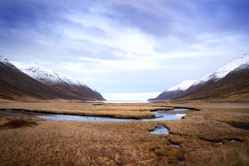
The receding glaciers left wide valleys and very old mountains, some quite high, behind in the northwest. The remaining rivers are among the best salmon grounds in Iceland. Especially during the time of the midnight sun the coastal regions are a true paradise for hikers, when the sun drops down to the horizon on the sea, only to rise again with magnificent colours. The further north you go, the more midnight sun you´ll see. A night hike on the northernmost point of Iceland, the island Grímsey is a very special experience.
The northeast is known for its lava fields, fissures and cracks in the rock as well as many hot spots and a few active volcanoes along the Mid-Atlantic Ridge. One of the most well-known high temperature regions is near Mývatn.
The north is not only interesting from a geological standpoint, the vegetation is also very interesting. The inland seems to be very meagre, as if only moss can grow on the lava fields.
In contrast, the coastal area has lush vegetation. A great variety of plants turn the land into blooming fields and also ensures animal diversity.
Mývatn is known for the many different bird species, you can watch whales in Húsavík and Eyjafjörður. Skagafjörður is known for various breeding lines of Icelandic horses. This area is also famous for herding sheep and horses down from mountain pastures in autumn and for many sagas and legends.
Because the northern landscape is so diverse, there are an unbelievable amount of things to do: a great variety of boat tours to watch whales, seals and birds, fishing, Jeep tours through the Highlands, hiking, bicycle tours, horseback riding, riding demonstrations, animal herding from the mountains, wild water rafting, diving, canoeing , paintball, swimming and relaxing in swimming pools and geo-thermal hotpots, golfing, sightseeing flights, skiing, snowboarding, cross-country skiing, ice climbing, ice fishing, dog sled driving, bird watching and many more.
Around 18,000 people live in Akureyri, the fourth largest city in Iceland and the largest in the north. As in all other parts of Iceland, the north offers a big variety of museums and other sights.
When driving from the east to the north, you can drive along the Ring Road past various lava landscapes, mountains and valleys to get from Egilsstaðir via Mývatn, Laugar, Akureyri, Varmahlíð and Blönduós to the west relatively quickly. If you´ve got some time and want to see some of the countryside, take the road along the fjords past many fishing villages. The 85th street leads from the eastern Vopnafjörður across the fjords to Húsavík and then back to the Ring Road. The 82nd begins in Akureyri and runs along the next fjords to Varmahlíð, whereby the road changes numbers in Ólafsfjörður to 76. The peninsula Skagi can be visited via the 745th street and the Vatnsnes peninsula via the 711th street.
Coming from Vopnafjörður, the northernmost village in the east, and taking the 85th street, you´ll first come to a little fishing village called Bakkafjörður. About 80 people live here. Take a short break in this picturesque village and then continue on to the next, slightly larger fishing village, Þórshöfn, with a population of about 380. Here you´ll find a supermarket, a restaurant, a swimming pool, beautiful landscape ideal for hiking, a folk and a sheep museum as well as a provider of kayak tours. Follow the street further into the north and you´ll reach Raufarhöfn. Here you´ll find everything you need: accommodations, a petrol station, a car repair shop, a swimming pool, a shop and medical care. This beautiful region makes hiking especially attractive. The arctic monument Heimskautsgerði, reminds us that the polar circle is only 17 kilometres north of the village. Drive another 15 kilometres along a dirt road and you´ll reach the northernmost point on the Icelandic mainland: Hraunhafnartangi. Follow 870th street through beautiful landscape and you´ll reach the fjord Öxarfjörður and the small village of Kópasker with a population just over 100. Here you´ll find all necessary facilities as well as a folk museum and an earthquake centre going back to the strong quake in 1976.
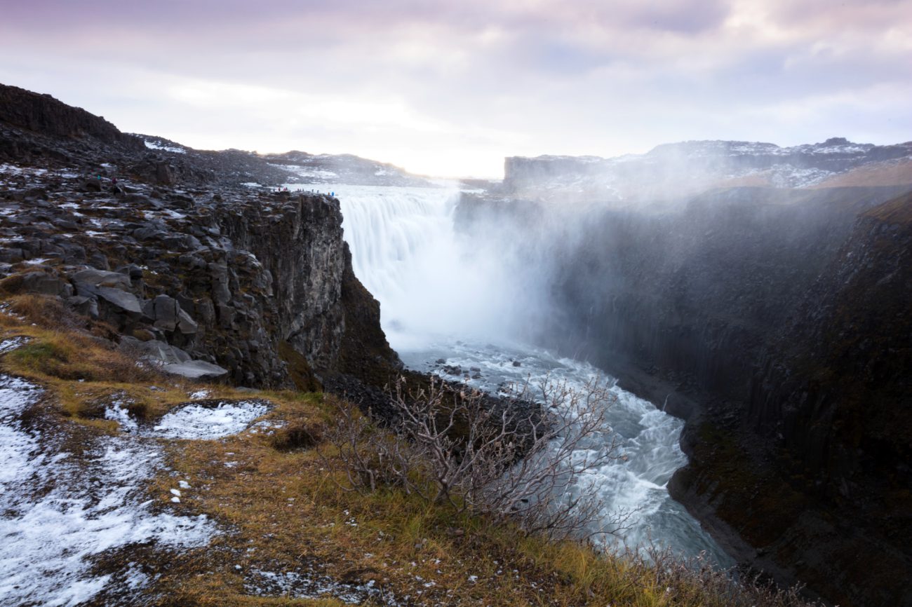
Continuing towards the south you return to 85th street. After traveling for about 35 kilometres you reach the Jökulsárgljúfur national park. This is where the river Jökulsá á Fjöllum has its river bed. Three strong glacial paths formed the Ásbyrgi canyon, also known as “Óðin´s foot print” because of the horseshoe shape. According to Icelandic lore Ásbyrgi is the capital of elves. Some special botanical features, such as an unusual silver-grey colour of birch bark, let people believe in the existence of elves to this day. There are good possibilities for mountain biking, hiking, horseback riding, golfing and diving in the surroundings of Ásbyrgi. From here you can either continue on the 85th street to get to Húsavík or take the 862nd street towards the south to see unusual mountains and canyons formed volcanoes in the national park and to see Dettifoss, the highest capacity waterfall in Europe.
Traveling on the 85th street from the Jökulsárgljúfur national park to Húsavík you pass by the bird cliff Tjörnes.
The Swede Garðar Svavarson was verifiably the first Viking to spend a longer amount of time in Iceland. About the year 875 he sailed around Iceland once, discovered that it is an island and named it after himself (Garðarsholmur). He spent one winter in Húsavík and founded a settlement. A monument near the school is dedicated to Garðar.
Today, the larger town is mainly known for whale watching tours. Besides many different types of whales you´ll also see birds (mainly puffins) and seals. The surroundings are great for hiking and horseback riding. The swimming pool is a good place to relax. Golfing is very popular during the summer, skiing and ski touring in the winter.
If you prefer cultural activities, visit the beautiful church or one of the museums.
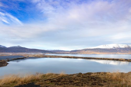
From Húsavík you can drive back to the Ring Road. From there you can get back towards Mývatn. If you take the 845th street from Húsavík you will pass by a peat house in an area that has been populated since the first settlement. The region around Mývatn is one of the most visited in northern Iceland. In the surroundings of the lake, you´ll find many natural phenomena that are a result of active volcanism. Mývatn lies on the Mid-Atlantic Ridge and is a part of the volcanic system Krafla.
The lake has a size of 37 square kilometres, is rather shallow with a maximum depth of 4.2 metres and lies in beautiful volcanic surroundings. Mývatn translates to “mosquito lake” and there are great swarms of mosquitos here during the summer. Because these insects make life easier for birds, you´ll find all species of ducks indigenous to Iceland here. The high temperature area Hverarönd is near Mývatn on the side of the mountain Námafjall. Many tourists come here to see the solfata (emission of gases and mud kettles) and fumaroles (emission of water steam). Another attraction is the natural pool Jarðböð. From Mývatn you can take Jeep tours into the Highlands, go hiking, mountain biking, horseback riding, golfing, drive dog sleds or snowmobiles or go cross-country skiing.
If you drive from Mývatn to Akureyri you´ll come to the town of Laugar. Here you´ll also find a swimming pool, a supermarket, a petrol station and a restaurant. Continuing on the Ring Road past Laugar is the unbelievably beautiful Goðafoss waterfall.
Some kilometres before reaching Akureyri you can take the 83rd street to Grenivík, a small fishing village offering leisure time activities or you can turn onto the 821st street, directly after the airport in Akureyri, and drive to the village of Hrafnagil with a population of 260 with a few activities for tourists.
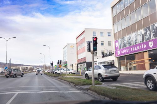
Akureyri has a population of 18,000 and is the capital of the north. Here you can really find everything you need. There is a big selection of shops, restaurants, cafés and accommodations as well as many sights and activities. The biggest ski area in Iceland is on the mountain Hlíðarfjall and in the Kjarnaskógur forest there are many hiking and mountain biking routes. In the city there are museums about air travel, industry, art, local celebrities and motorcycles. You can relax in the botanical garden or watch whales on a boat tour. Further activities are Jeep tours, hiking, mountain biking, horseback riding, golfing, ice fishing, dog sledding or relax in one of the swimming pools or geo-thermal Hotpots.
The next stretch goes from Akureyri along the 82nd street across the Eyjafjörður further into the north.
The first stop is the small fishing village of Hjalteyri. Here you can sometimes watch whales. Next on the route are two fishing villages, Hauganes and Árskógssandur. In Hauganes you´ll find a restaurant with a visitor´s centre and a whale watching tour guide. From Árskógssandur you can drive to the island of Hrísey. Hrísey is the second largest island in Iceland and has been inhabited since the first settlement. Today, it´s a great place to hike, watch countless birds, go to the new swimming pool or inform yourself in the museum about former shark hunting days.
Back on the mainland, it´s only a short trip to the large fishing town of Dalvík. You´ll find a good infrastructure and many activities being offered such as whale watching tours, horseback riding, swimming in geo-thermal pools, visit museums, skiing, hiking and canoeing in the near nature-protection area.
From Dalvík there is a ferry three times a week to the island of Grímsey. The three-hour trip is worth taking because only here you can experience the midnight sun in all its glory. The island is the only part of Iceland directly on the polar circle and is the northernmost point that is inhabited. In Grímsey you can hike, swim, dive and watch the fishermen at work.
The next beautiful and idyllic town on the mainland is called Ólafsfjörður. Here you´ll find a thermal pool, a golf course, a ski and snowboard area and a museum of natural history.
From Ólafsfjörður you can drive to Siglufjörður through a two-part tunnel with a total length of 11 kilometres. In the 600 metres between the two tunnels you look into a valley and the Héðinsfjörður. This is where a plane crashed against the mountain in 1947.
There is great skiing, hiking, golfing and swimming in Siglufjörður.
Next along the 76th street is the village of Hofsós. The highlights in this town are a swimming pool directly next to the ocean with a wonderful view of the Skagafjörður and the Pakkhúsið, one of the oldest buildings in Iceland with museum. Around 4 kilometres away is the peat church Gröf.
Continuing onto the next town, you reach Hólar. The last catholic bishop, Jón Arason, was captured and executed here by the men of the Danish king. This historical event has given the town fame. To this day Hólar has a cathedral. Even though Hólar only has a small population, there is always something happening, because this is the sight of the trade school for horse and fish breeding as well as for tourism. There is a historic horse centre and a historic path through the centre.
Following the 76th street you´ll get to the Ring Road and to Varmahlíð. This town is a possible entry point into the Highlands. Many rivers flow from the Highlands past Varmahlíð in the direction of the sea. Here you´ll also find a geo-thermal area. Varmahlíð is known as a beautiful area for horseback riding and river rafting tours. Because a few warm inflows end here, you can make a stop at a few spots along the tour, take some hot water from the river and make yourself a cup of hot chocolate. Due to the thermal area there are three geo-thermal pools. If you drive south from Varmahlíð on the 725th street, you´ll get to the Highlands – although only drivable with a Jeep.
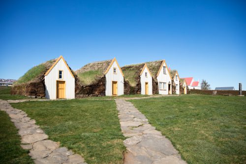
From Varmahlíð take the 75th street to Sauðárkrókur. On the way you´ll pass the museum farm Glaumbær.
Sauðárkrókur is the biggest city in the northwest of Iceland and well-known among horse fans because several breeding lines have their origins here. There are still some very good breeders in the area. The city has a good general infrastructure and a factory outlet store selling sheep skin and fish leather. There is good hiking, you can go to the swimming pool, go skiing and visit an old wooden church as well as the museum of local history.
From Sauðárkrókur you can drive around the peninsula of Skagi on the 745th street. Along the way is the town of Skagaströnd. Here you´ll find an extended hiking area, two museums and a swimming pool.
After a drive of a few kilometres, you return to the Ring Road in the community of Blönduós. In the town with a population of around 800, you´ll find a good infrastructure for the inhabitants as well as for tourists, several museums, the stone church Þingeyrar and a a true paradise for all fishermen, the rivers here are among the richest in salmon in the whole of Iceland. As in most other towns, you´ll also find a swimming pool.

A highlight of nature is the Vatnsnes peninsula. Take the 711th street from the Ring Road towards the north. You come to the basaltic rock Hvítserkur. According to lore this is a troll, who was turned into stone, when he was trying to throw stones at the church Þingeyrar on the other side of the fjord. Further to the north is the biggest seal colony in Iceland. Here you can hike in beautiful natural surroundings. In Hvammstangi, a town on the western side of the peninsula, you´ll get a lot of information at the seal centre and can take a seal watching tour on a boat. Horseback riding tours are also available. A small shop offers products made of wool directly from the manufacturer.
The small settlement Laugarbakki, near the Ring Road, only has 40 inhabitants. Still there is a large variety of riding tours available. The village has a farmers market and a big history in sagas. The last settlement before turning either towards the Westfjords or towards Reykjavík via the paved Highland road is Borðeyri. Here you´ll find a museum and nice hiking, mountain biking and horseback riding routes.

Text & Images: Eva Frischling
Excerpt from the book “Lebensgefühl Island” / “Soul of Iceland”
Eva’s website
Eva’s instagram
Eva’s facebook page
A land of fire and ice, with more sheep than inhabitants, characterized by a unique nature! This is just a brief description of such a diverse country. While a volcano may erupt on one side of the country, you can hike a glacier, admire the Northern Lights, or take a bath in a hot spring on the other side of the country - at the same time.
This not only speaks for diversity, but also for spontaneity, which is also reflected in the changeable weather in Iceland. A popular Icelandic saying is "If you do not like the current weather, just wait for five minutes".
In contrast to this inconsistency, one thing is constant and that is the enthusiasm for Icelandic horses! The Vikings brought horses to the island in the 9th century.
To find out more about Iceland, you can find travelogues, reports, or interesting facts here in the UNDRA Journal!